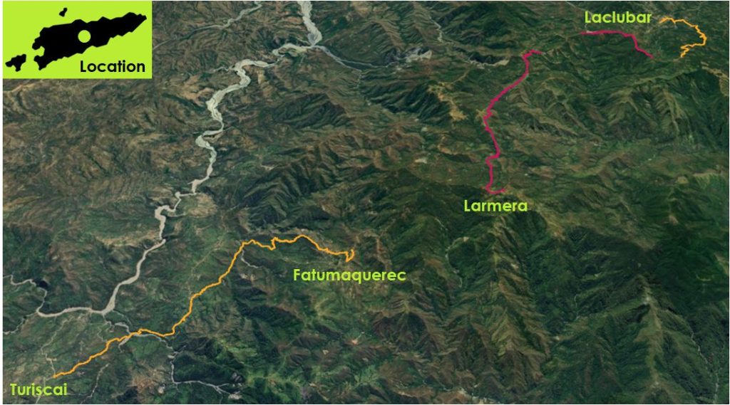
This moderate to hard 3 day hike involves ~1,200m of ascent and ~2,000m of descent as you walk between Turiskai in Manufahi and Laclubar in Manatuto through remote and spectacular parts of Timor-Leste.
Dili
7:30 AM Local Time (GMT+9)
TBC please inquire as it varies based on the number of people
Confirmation of tour services for groups not less than 21 days prior to tour commencing.
20% deposit of total invoice is due at time of confirmation.
Full payment of invoice due immediately if notice of confirmation is less than 14 days prior to tour commencing.
The deposit, being 20% of total invoice is forfeited if cancelation is notified less than 7 days.
Timor-Leste is a hot place to hike. Around the coast expect day time temperatures above 30C all year round, and even in the mountains it is commonly above 20C, and feels hotter in the sunshine. The best months to hike in Timor-Leste are June and July, when it is slightly cooler, and dry, while still retaining some of the lush greenery from the wet season. Toward the end of the dry season in September the landscape is dusty and parched.
Heat stroke is probably the biggest risk while hiking in Timor-Leste. At worse heat stroke can cause death, but even mild heat stroke can cause headaches and vomiting. The combination of heat, humidity and hills, is challenging as sweating is not effective in cooling down the body. These are good approaches…
Drink a lot of water, more than you may be used to drinking. Dehydration is a risk given the amount that you are likely to be sweating. If you don’t need to go to the toilet, then you’re not drinking enough.
Add electrolytes / hydrolytes to your water. You can buy these cheaply in pharmacies and they provide your body with a welcome boost of sugar and salts to help replace what is lost through sweating.
Shade is essential to help your body cool down. Sunhats are a must, along with resting regularly in the shade.
Wearing a wet cloth around the neck, wetting your hat or shirt, or pouring water on the back of your neck are all effective and refreshing!
The hike is mostly on rough tracks used by locals, with some dirt road walking in places. There aren’t really any managed hiking tracks in Timor-Leste like you may find in other countries. There is almost no signage either, and often a multitude of tracks make it easy to get lost without closely following a map or a local guide.
Nearly half the land in Timor-Leste is at a slope of 40 degrees or more, so expect to generally be either going up or down a steep hill. Soils are often easily eroded by rainfall so expect loose stones underfoot as standard, but tree roots aren’t an issue. When walking along roads locals walk in the same direction as traffic, i.e. on the left-hand side, and drivers will use their horn if they’re approaching closely from behind.
There may be some river crossings required. Later in the dry season rock hopping is usually possible, but in some places this may not be possible. Either remove your boots, or cross in them, as they dry quickly in the hot climate.
Although Timor-Leste is home to poisonous animals and plants, you are highly unlikely to come across them while hiking. Snakes are rarely seen. The biggest risk is from mosquitoes carrying Dengue or Chikungunya, so take suitable precautions, particularly at the start and end of the day if hiking in the wet season or early in the dry season.
The most common animal you’ll come across hiking are dogs, which are almost guaranteed at every Timorese house. They are likely to bark, much less likely to bite, but care should be taken. As a general rule of thumb, the more remote the house, the greater the reaction. Rabies had been eradicated from Timor-Leste, but there was a localised outbreak in western Timor-Leste in 2024. It is best to move quickly (but not run) past dogs, and the following approaches can be taken in order of escalation…
Ignore them, avoid eye contact
Get the attention of their owner by calling out bondia (good morning) or boa tarde (good afternoon)
Reach down to the ground to pick up (or look like you are picking up) a rock or wave a hiking stick
All our multi-day hiking trips are camping, but with a Timorese flavour! Campsites are not that common, but every village has a school and local government offices. With permission from the leader of the local community we may camp at these sites. They provide good shelter and usually have toilet and washing facilities available.
There are very few shops in the areas in which we hike, and cooking facilities are limited to the gas cookers we bring with us, so expect simple but tasty and filling meals. Breakfast may be muesli, eggs, and fresh bread. Lunch is cooked on the go, and may be noodles, eggs, cheese and bread. Popcorn may be made as a pre-dinner snack. Dinner may be rice, meat (usually chicken), tinned tuna, and whatever vegetables we can buy locally. If you have any dietary requirements or requests please let us know.
Our support vehicle will always have sufficient drinking water, usually in 1.5 litre bottles, so you can resupply at the start and end of each day.
Most of the sites we camp at will have some toilet and washing facilities, but expect them to be basic. Squat toilets and bucket showers are standard. You may want to bring jandals to wear. If there is no toilet available the crew will dig a hole and erect a toilet tent.
A typical support crew will include a lead hiking guide, driver, and a supporting crew who will carry the lunch and cooking gear during the day. Tipping is not expected but would be welcomed by the team.
Mobile phone coverage is limited outside of the main towns and larger villages. Of the three local providers, Telemor tends to have the best coverage.
Devices can be charged using the support vehicle USB ports, and some of the places we camp may have mains electricity.
Up around 6am, breakfast, pack up camp, and start hiking between 7.30am and 8am. Lunch is around noon. Arrive at camp between 4pm and 5pm. Dinner around 7pm.
What to Expect:
7.30am Enjoy the mountain scenery of Aileu and Ainaro on the 4 hour drive to Turiscai. Stop to explore the remains of the Portuguese colonial Pousada, before heading further east to eat lunch and start hiking. Walk down to a tributary of the North Laclo River, the longest river in the country. From here head up to Tetuluai and across to Fatumaquerec, passing a site where Timor-Leste independence leadership hid from Indonesian troops during the occupation.
Duration:5 hours
Distance:13.4km
Elevation:Up 734m Down 527m
Transfer from Fatumaquerec to Larmera by vehicle to avoid extensive road walking. This is tougher day than yesterday as we cross rugged landscapes, but the effort involved is rewarded with spectacular views. Enjoy a rest in the town of Laclubar, home to busy Sunday markets and a sizeable church.
Duration:6-7 hours
Distance:18.9km
Elevation: Up 884m Down 1,509m

It is a 3 hour scenic drive back to Dili, travelling through the interior of Manatuto municipality, before returning along the beautiful coastal road to the capital. We’ll stop just outside Laclubar at the Gruta Vila Maria Rulalan-Laclubar shrine, which offers panoramic views.