Do what less than 100 people have ever done, and cross the whole country on foot, from the capital Dili to the south coast of Timor-Leste, climbing the highest mountain (Mt Ramelau) on the way. This is true adventure, walking across the mountainous spine of the island, enjoying varied and spectacular scenery throughout. Note that there are different routes available depending on your appetite for summiting mountains and road walking, which are happy to discuss with you. This 7 day itinerary follows the route taken in July 2024 (which was impacted by unseasonal weather half way through), but will give you a good idea of what the Coast2Coast hike involves.
Eco Discovery Timor-Leste is a sustainable tourism company dedicated to showcasing the natural beauty and cultural heritage of Timor-Leste. They offer a range of eco-friendly tours, including hiking, birdwatching, snorkeling, and cultural experiences, all designed to connect visitors with the country’s diverse landscapes and vibrant communities. With a focus on conservation and responsible travel, Eco Discovery aims to promote environmental awareness and support local economies, providing unforgettable experiences while protecting Timor-Leste’s unique ecosystems.
Dili (precise location will be confirmed on enquiry before arrival)
7:00 AM Local Time (GMT+9)
$2,160 per person for group of 3 people. For smaller or larger groups please inquire.
The deposit, being 20% of total invoice is forfeited if cancelation is notified less than 7 days.
Timor-Leste is a hot place to hike. Around the coast expect day time temperatures above 30C all year round, and even in the mountains it is commonly above 20C, and feels hotter in the sunshine. The best months to hike in Timor-Leste are June and July, when it is slightly cooler, and dry, while still retaining some of the lush greenery from the wet season. Toward the end of the dry season in September the landscape is dusty and parched.
Heat stroke is probably the biggest risk while hiking in Timor-Leste. At worse heat stroke can cause death, but even mild heat stroke can cause headaches and vomiting. The combination of heat, humidity and hills, is challenging as sweating is not effective in cooling down the body. These are good approaches…
The hike is mostly on rough tracks used by locals, with some dirt road walking in places. There aren’t really any managed hiking tracks in Timor-Leste like you may find in other countries. There is almost no signage either, and often a multitude of tracks make it easy to get lost without closely following a map or a local guide.
Nearly half the land in Timor-Leste is at a slope of 40 degrees or more, so expect to generally be either going up or down a steep hill. Soils are often easily eroded by rainfall so expect loose stones underfoot as standard, but tree roots aren’t an issue. When walking along roads locals walk in the same direction as traffic, i.e. on the left-hand side, and drivers will use their horn if they’re approaching closely from behind.
There may be some river crossings required. Later in the dry season rock hopping is usually possible, but in some places this may not be possible. Either remove your boots, or cross in them, as they dry quickly in the hot climate.
Although Timor-Leste is home to poisonous animals and plants, you are highly unlikely to come across them while hiking. Snakes are rarely seen. The biggest risk is from mosquitoes carrying Dengue or Chikungunya, so take suitable precautions, particularly at the start and end of the day if hiking in the wet season or early in the dry season.
The most common animal you’ll come across hiking are dogs, which are almost guaranteed at every Timorese house. They are likely to bark, much less likely to bite, but care should be taken. As a general rule of thumb, the more remote the house, the greater the reaction. Rabies had been eradicated from Timor-Leste, but there was a localised outbreak in western Timor-Leste in 2024. It is best to move quickly (but not run) past dogs, and the following approaches can be taken in order of escalation…
All our multi-day hiking trips are camping, but with a Timorese flavour! Campsites are not that common, but every village has a school and local government offices. With permission from the leader of the local community we may camp at these sites. They provide good shelter and usually have toilet and washing facilities available.
There are very few shops in the areas in which we hike, and cooking facilities are limited to the gas cookers we bring with us, so expect simple but tasty and filling meals. Breakfast may be muesli, eggs, and fresh bread. Lunch is cooked on the go, and may be noodles, eggs, cheese and bread. Popcorn may be made as a pre-dinner snack. Dinner may be rice, meat (usually chicken), tinned tuna, and whatever vegetables we can buy locally. If you have any dietary requirements or requests please let us know.
Our support vehicle will always have sufficient drinking water, usually in 1.5 litre bottles, so you can resupply at the start and end of each day.
Most of the sites we camp at will have some toilet and washing facilities, but expect them to be basic. Squat toilets and bucket showers are standard. You may want to bring jandals to wear. If there is no toilet available the crew will dig a hole and erect a toilet tent.
A typical support crew will include a lead hiking guide, driver, and a supporting crew who will carry the lunch and cooking gear during the day. Tipping is not expected but would be welcomed by the team.
Mobile phone coverage is limited outside of the main towns and larger villages. Of the three local providers, Telemor tends to have the best coverage.
Devices can be charged using the support vehicle USB ports, and some of the places we camp may have mains electricity.
Up around 6am, breakfast, pack up camp, and start hiking between 7.30am and 8am. Lunch is around noon. Arrive at camp between 4pm and 5pm. Dinner around 7pm.
What to Expect:
7am Get picked up from your hotel and drive 30 minutes to Fatisi, on the outskirts of the Dili region, to avoid busy road walking in the city. Walk up part of a tributary to the Comoro River, one of the largest river systems in the country, before a steep ascent up into the hills of Ermera. Follow a ridgeline home to a number of villages, before reaching the beautiful lagoon of Seloi Craic (pictured below) to camp for the night.
Duration:6 hours Distance:11.9km Elevation:up 991m, down 156m
See whats in store ahead! ->


Cross about two thirds of the beautiful municipality of Aileu in one day, walking through villages and enjoying big views from the ridgelines. Walk out of Seloi Craic through rice fields before heading up into the hills before setting up camp in the panoramically situated village of Hahulo Ramsu.
Duration:8 hours Distance:15.4km Elevation:up 744m, down 370m


Another big day, but with views to reward the effort, particularly in the afternoon as we summit Mt Maubo (pictured below), which offers great views of the 2,986m Mt Ramelau (pictured on the cover), the highest point in Timor-Leste. We cross crosses three municipalities (Aileu, Ermera, and Ainaro), through atmospheric forest before camping with a view with Mt Ramelau.
Duration:8 hours Distance:14km Elevation:up 1,018m, down 195m


Hatu Builico (pictured below), the highest village in Timor-Leste, is a short drive from Usululi, avoiding hiking a dangerous ridgeline up Mt Ramelau. It is a beautiful village, and we’ll spend a few hours walking around looking at the Former Portuguese colonial administrative building, Uma Lulik (traditional Timorese sacred houses), impressive new church, the markets (if they’re on that day), and visit a cemetery with a view.
In the afternoon head up to the summit of Mt Ramelau to enjoy sunset, which unlike sunrise, you’re likely to have to yourself. Enjoy a night in a guesthouse, before returning to camping for the rest of the trip
Hatu Builico Duration:3 hours Distance:6.8km Elevation:up and down 215m
Mt Ramelau Duration:4 hours Distance:10.5km Elevation:up and down 600m

One of the more spectacular days as we walk out of Hatu Builico, through rarely hiked areas, down to the incredible Dokomali Falls, probably the best waterfall in Timor-Leste.
Duration:6 hours Distance:13.6km Elevation:up 106m, down 1,024m


Mt Kablaki (2,062m) may only be the fourth highest mountain in Timor-Leste, but it is one of the most difficult and dangerous. We take a slightly easier traverse around the side of the mountain, offering incredible views, and the most challenging terrain of the whole Coast2Coast hike. Paths are usually overgrown or non-existent, and shoulder high grass is common, but the views are more like the European Alps than what you would imagine in Southeast Asia.
Duration:6 hours Distance:5.9km Elevation:up 566m, down 628m

To avoid significant road walking you can use the support vehicle to hike the most scenic areas of Manufahi, including traditional Timorese houses south of Same, along by the significant Caraulun River, and head to Betano (pictured below) on the south coast where Australian troops landed (and were evacuated from) during WW2.
Duration:5-6 hours Distance:13km Elevation:up 100m, down 100m

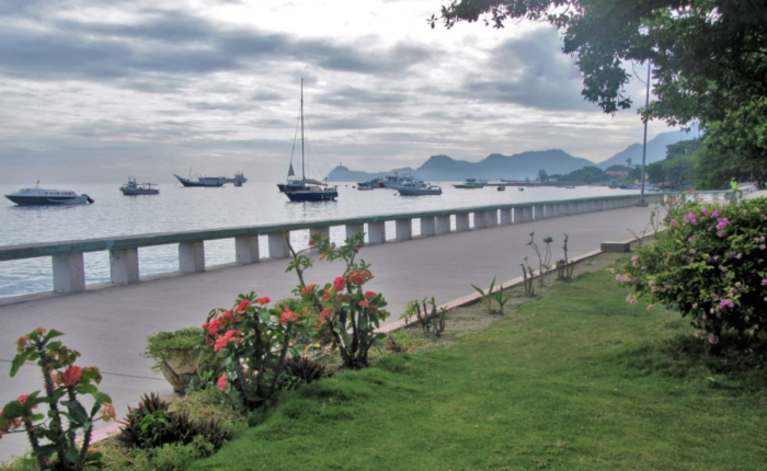
Relax on the 4 hour drive back from Same to Dili, travelling through at higher speeds the landscapes you’ve just spent a week walking through. Perhaps stop for a refreshing dip at the natural swimming pool near Same (pictured below).


Established in 2005, Eco Discovery are one of the longest running and most reputable tour operators in Timor-Leste. They are Timorese owned and operated. I’ve been on multiple trips with them, from day adventures, to an 8 day epic crossing the country on foot. They are well organised, responsive, and know Timor-Leste as well as anyone. They can organise pretty much any type of trip, and have the greatest experience of any Timorese operators in running hiking trips.